PORTFOLIO

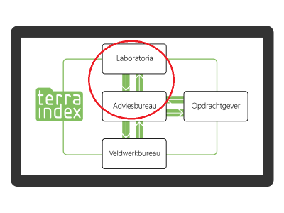
TI Web Lab assignments (sending and automatic import of results)

Gerealiseerd June 27, 2017
Klant n.v.t.
Technieken n.v.t.
Delen
Bekijk slideshow Lees verder

Project leader/Information-analyst for the extension of web application TerraIndex with labassignments exchange.
Connecting with Laboratories’ LIMS (Laboratory Information Management System) and exchange data based on SIKB0101 exchange format.
Automatic import of results when available and downloadable at the laboratories’ LIMS.

BoToVa-Service legislation testing

Gerealiseerd June 26, 2017
Klant n.v.t.
Technieken n.v.t.
Delen
Bekijk slideshow Lees verder

Project leader/Information-analyst/Developer for creating and maintenance BoToVa-Service (Bodem Toetsing en Validatie-service) with all dutch legislation testings.


www.botova-service.nl


www.botova-service.nl/testing


Extend TerraIndex with measurement series for fieldworkers of Arcadis

Gerealiseerd May 3, 2017
Klant n.v.t.
Technieken n.v.t.
Delen
Bekijk slideshow Lees verder

Project leader/Information-analyst for the extension of the fieldworks App of TerraIndex, with the possibility to easily insert measurement series.

Automatically exchange/synchronize these measurements to the office application of TerraIndex.


Create Map Layers (WMS/WFS) with soil survey data for use in external Gis

Gerealiseerd April 11, 2017
Klant n.v.t.
Technieken n.v.t.
Delen
Bekijk slideshow Lees verder

Team Lead and Information-analyst for the creating map layers for each licensed company to let them use their own data in an external GIS viewer. All TerraIndex users can login and get their data, created by binding Geoserver to the TerraIndex users database en license management.
The project was set up small, all requirements and delivery prototypes are done in discussion with experts, based on a lean startup way.


TerraIndex App with new intuitive working Map layers

Gerealiseerd January 11, 2017
Klant n.v.t.
Technieken n.v.t.
Delen
Bekijk slideshow Lees verder

Team lead, Information-analyst, Backend developer for creating a new intuitive map with layers for all soil survey data that is possible to geolocate.
The map has possibilities to draw new, edit and delete points, lines and polygons.


AquaIndex for Dunea, App for monitoring Groundwater levels

Gerealiseerd November 11, 2016
Klant n.v.t.
Technieken n.v.t.
Delen
Bekijk slideshow Lees verder

Project leader/Information-analyst and Backend Developer for implement TerraIndex for usage in water monitoring rounds. This extracted version of the TerraIndex interface is published as AquaIndex, but communicates with the same backend.

Together with Dunea we have made their process of groundwater level survey and exchanging data with the office possible, in an intuitive interface extracted from TerraIndex.

Direct access with DataLoggers via USB is made from WinJS through C++,  to request all data directly from the device.

All survey data is directly synced from the field and users can work together in the same monitoring round.

Extend IM-Metingen with UMAquo metingen

Gerealiseerd September 14, 2015
Klant n.v.t.
Technieken n.v.t.
Delen
Bekijk slideshow Lees verder

Project leader/Information-analyst to extend IMMetingen exchange format, for soil survey data with water survey data. The format UMAquo metingen is fully supported now by the IMMetingen format, with some improvements.


www.aquo.nl

www.geonovum.nl/immetingen


IMMetingen is in combination with SIKB: IMSIKB0101.


www.sikb.nl

www.geonovum.nl/sikb


Requirements and Functional Designs for public tender zwemwaterregister.nl

Gerealiseerd July 11, 2012
Klant n.v.t.
Technieken n.v.t.
Delen
Bekijk slideshow Lees verder

Information-analyst for IHW (Informatiehuis Water) in contract of IPO (InterProvinciaal Overleg) to setup a definition for public tender for swim water quality. A public and internal application with GIS map for all ‘Waterschappen’ to register their water qualities during the summer season.


www.zwemwater.nl

also available as App on Android and iOS.